
Ex 14:1-4 God tells Moses to turn back north in order to get the Pharaoh to pursue them.
The Israelites camp at Pi Hahiroth (‘Mansion of Hahiroth’) between Migdol (meaning ‘a fortified tower’, on the Way of Shur near the border of Egypt) and the Gulf of Suez, opposite the Philistine temple of Baal Zephon (‘Baal (Lord) of the north’). The exact site of Pi Hahiroth is unknown, but it lies near Ismalia on the route taken today by the Suez Canal through the area of shallow salt marshes and lagoons now known as the Bitter Lakes (see 4 on Map 44).
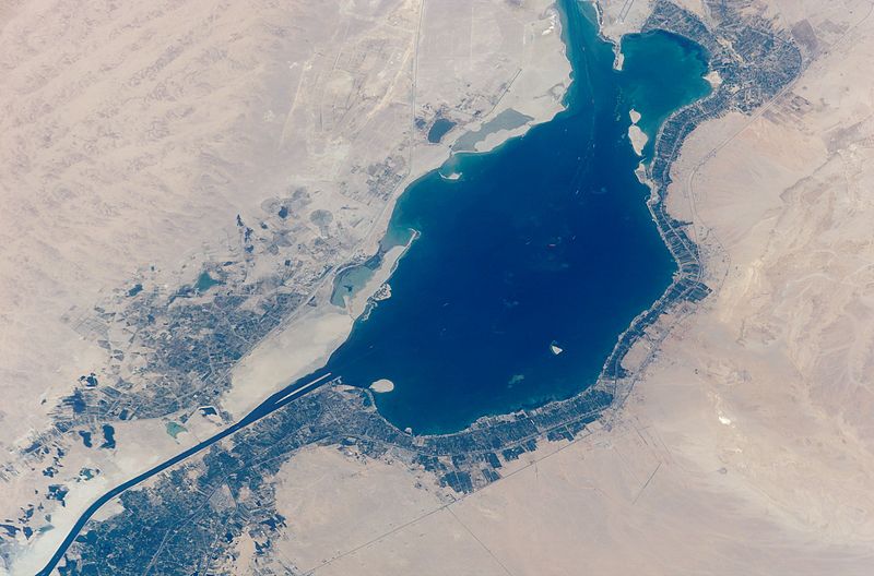
The Great Bitter Lake near Ismalia (NASA)
Ex 14:5-14 The Pharaoh (probably Pharaoh Dudimose) sets off with six hundred war chariots and catches up with the Israelites at Pi Hahiroth among the Bitter Lakes.
Ex 14:15-31 The Israelites travel through the tidal salt marshes to the north of the Gulf of Suez and cross the shallow Sea of Reeds while Moses holds out his hand and the LORD drives the water back “with a strong east wind” (Exodus 14:21) (see 4 on Map 44). The Egyptians pursue the Israelites but their chariot wheels become stuck in the mud. The water returns as the wind subsides, covering the chariots and drowning the heavily armed Egyptian soldiers. The Israelites are able to arm themselves with the weapons abandoned by the Egyptians.
Crossing the Sea of Reeds
The Biblical account of the Israelites’ escape from Egypt comes to a climax when pharaoh’s chariots pursue the fleeing Israelites, but the Egyptian soldiers are drowned when the sea returns and floods the path that the Israelites have trodden only hours earlier.
While Hollywood films (and perhaps even the Bible itself) tend to exaggerate the cause of the military disaster that struck the Egyptians, there is no doubt that local winds and tides are quite capable of producing the kind of conditions described in the Bible.
The first point to bear in mind is that the Israelites did not cross the Red Sea but the Sea of Reeds. The Hebrew ‘Yam-suf’ (meaning Reed Sea) was translated incorrectly in the King James Version of the Bible and the unfortunate error has passed into folk history. In reality, the Israelites’ route crossed the shallow depression now occupied by the Suez Canal in the region of the tidal salt marshes and reed beds near the Bitter Lakes to the south of Ismalia (Al-Ismalliyah).
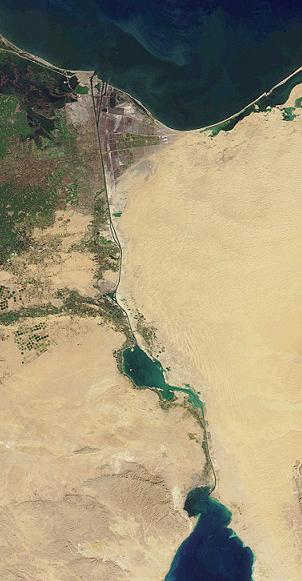
The Suez Canal (NASA)
The Israelites crossed the Reed Sea
(Hebrew: Yam-suf) between the
Bitter Lakes and the Gulf of Suez
(near bottom of photo)
When Moses raised his arms and a strong easterly wind drove the waters back, the Israelites were able to walk across the shallow Sea of Reeds. When the wind stopped blowing (and the rising tide probably flooded back), the water returned and pharaoh’s chariots, already bogged down in the heavy mud, were washed away.
The average daily variation in sea level at Port Tawfik where the Suez Canal joins the Gulf of Suez (at the northern end of the Red Sea) is currently nearly 4 feet / 1.2 metres. (It is roughly half this amount at Port Said, at the northern end of the tidal Suez Canal). Hydrological research carried out in the Gulf of Suez in 1996 showed that daily fluctuations are due to a combination of both winds and tides. Where the water is particularly shallow (as in the Bitter Lakes), the effect of the prevailing north east winds on the water levels is actually greater than the effect of the tides.
Dating the Exodus from Egypt
During the 19th century, Biblical scholars dated the Exodus to the reign of Pharaoh Ramesses II (traditionally dated 1279 – 1213BC). This was based on the statement in Exodus 1:11 that the Israelites were forced to build the store cities of Pithom and Raamses. It was assumed that Raamses referred to Pi-Ramesses (or Piramesse), the new capital built by Ramesses II (traditionally dated to c.1250BC).
However, 1 Kings 6:1 states that the first Temple was built 480 years after the Exodus. As Solomon built the Temple in 968BC, this would imply that the Exodus began in c.1447BC – 200 years earlier than the traditional date for the building of Pi-Ramesses.
Also, in Judges 11:26, Jephthah tells the King of Ammon that it is 300 years since Israel occupied the land of Moab. As the Israelites settled in Moab forty years after the Exodus, and Jephthah judged the people from c.1108-1102 BC, this places the Exodus 340 years earlier in c.1448-1442BC – also 200 years before the building of Pi-Ramesses. It is clear from the Biblical evidence that the Exodus took place in c.1447BC, not in 1250BC as suggested by Victorian scholars.
So why does the Bible state that the Israelites were forced to build the store cities of Pitham (Pi-Atum) and Raamses (Pi-Ramesses)? The answer is that the name Raamses refers to the earlier city of Avaris, built on the same site as Pi-Ramesses two hundred years before Ramesses II built his new capital here (see the feature on Avaris / Piramesse earlier in this section).
By the time the Book of Exodus was written in the 6th century BC – some 600 years after the building of Piramesse on the site of Avaris – the earlier name of the city had long been forgotten.
As the Exodus took place in c.1447BC, the pharaoh at the time of the Exodus was not Ramesses II – as Biblical scholars believed for many years – but probably Pharaoh Dudimose (c.1457 – 1444BC).
Ex 15:1-21 Moses and the Israelites offer a song of thanksgiving to God for deliverance from their enemies: “The other nations will hear this and tremble with fear; terror will take hold of the Philistines. The leaders of the tribes of Edom will be very frightened; the powerful men of Moab will shake with fear; the people of Canaan will lose all their courage.” (Exodus 15:14-15).
Ex 15:22 The Israelites travel through the Desert of Shur for three days (see 5 on Map 44).
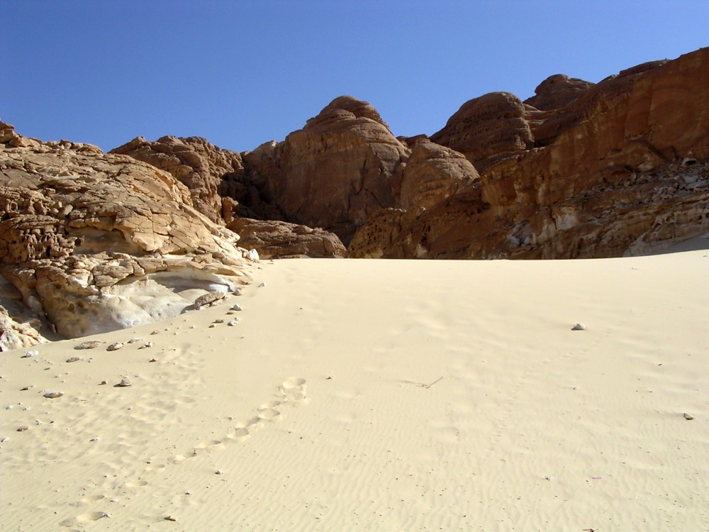
Desert in the Sinai Peninsula
Ex 15:23-26 At Marah (meaning ‘bitter’) the water is too bitter to drink until Moses throws in a piece of wood to sweeten it.
Ex 15:27 They reach Elim (meaning ‘terebinth’ or ‘turpentine’ trees), a desert oasis with twelve springs and 70 palm trees (see 6 on Map 44). This oasis with twelve springs on the desert road to Sinai is now known as Ain Mousa – the ‘Spring of Moses’.
Ex 16:1-13 They leave Elim and cross the arid Desert of Sin en route to Sinai (see 7 on Map 44). The Israelites complain they are hungry, so God promises to feed them. That evening, a large flock of quails - a migratory bird - flies into the camp.
Ex 16:14-36 Each morning, the Israelites are fed with ‘manna’ (meaning ‘what is it?’) - a small white seed lookimg like frost on the ground and tasting like wafers made with honey.
Ex 17:1-5 They set out from the Desert of Sin and make camp at Rephidim (located possibly on the site of Serabit el-Khadim) where there is no water. The people complain about their thirst.
Ex 17:6-7 Moses strikes the rock and water flows from it. The place is called Massah (‘testing’) and Meribah (‘complaining’) because the Israelites complained and put God to the test when they asked “Is the LORD with us or not?” (Exodus 17:7).
Ex 17:8-14 A large force of Amalekites attack the Israelites at Rephidim but Joshua’s forces defeat them. Moses watches the battle from a neighbouring hilltop and encourages the Israelites by raising his arms to the LORD in prayer. The Israelites amass more weapons and armour from the defeated Amalekites.
Ex 17:15 Moses celebrates the victory by building an altar called “The LORD is my Banner” (Exodus 17:15).